Showing posts with label Area C. Show all posts

Friday, July 11, 2025

Settlements versus Villages, Neighborhoods, Colonies: Deciding Factor in Politics, Wars

Nadene Goldfoot                                                           

                                        Pensacola, Florida Today

In 1559, a Spanish expedition led by Tristán de Luna y Arellano, brought 1,500 soldiers, colonists, slaves, and Aztec Indians in 11 ships from Veracruz, Mexico, to Pensacola to begin the Spanish colonization of the northern Gulf Coast. One month after Luna and his expedition arrived, the colony was struck by a hurricane, sinking many of their ships and devastating their food supplies. After two years, the remnants of the colony were rescued by Spanish ships and returned to Mexico. The Luna settlement inhabited Pensacola from 1559 to 1561, which predates the Spanish settlement in St. Augustine, Florida, by six years, and the English settlement in Jamestown, Virginia, by 48 years. This makes Pensacola the site of the first multi-year European colonial settlement ever archaeologically identified in the United States.

The first permanent European settlement in what is now the United States was St. Augustine, Florida, established by the Spanish in 1565.  Today,  St. Augustine is a city on the northeast coast of Florida. It lays claim to being the oldest city in the U.S., and is known for its Spanish colonial architecture as well as Atlantic Ocean beaches like sandy St. Augustine Beach and tranquil Crescent Beach. Anastasia State Park is a protected wildlife sanctuary. The Castillo de San Marcos is a 17th-century Spanish stone fortress with views of the St. Augustine Inlet. ― Google Founded: September 8, 1565        

        Jamestown Colony-skipping the word settlement

While Jamestown, Virginia is often cited as the first English settlement, it was founded in 1607, significantly later than St. Augustine. It was established by the London Company as "James Fort" on May 4, 1607 O.S. (May 14, 1607 N.S.), and considered permanent, after brief abandonment in 1610. It followed failed attempts, including the Roanoke Colony, established in 1585. Despite the dispatch of more supplies, only 60 of the original 214 settlers survived the 1609–1610 Starving Time. In mid-1610, the survivors abandoned Jamestown, though they returned after meeting a resupply convoy in the James River..

The Spanish, then British started settlements on this new land  They had a hard time surviving, but one did.

      Wilmington  

  Delaware was the first state to be declared in the USA. It ratified the U.S. Constitution on December 7, 1787, making it the first state to join the Union. This event earned Delaware the nickname "The First State" according to Delaware.gov. The first settlement in Delaware was called Zwaanendael. Established by Dutch traders in 1631 near present-day Lewes, this settlement was intended for whale hunting and agriculture. The name Zwaanendael means "Valley of the Swans" in archaic Dutch. However, this initial settlement was short-lived, as conflicts with local Native Americans resulted in its destruction in 1632. The first permanent European settlement in Delaware was Fort Christina, established by Swedish settlers in 1638. It was located at present-day Wilmington and was part of the New Sweden colony. Wilmington, Delaware, was first settled by Europeans in March 1638, when Swedish colonists established Fort Christina, now the site of Wilmington. The city was officially incorporated much later, first as a borough in 1739 and then as a city in 1832according to the City of Wilmington (DE) (.gov). 

The USA was founded on July 4, 1776. Before this date, communities that arose were called Settlements; but afterwards, became cities.  Settlements appear to me to be an antiquated term, making me think of cowboys and Indians around a Fort,  but google thinks differently:

There are various types of settlements, commonly categorized as:
  • Rural Settlements: Characterized by lower population density and often reliant on agriculture or natural resource extraction.  (usa firsts)
  • Urban Settlements: Densely populated centers of commerce, industry, and governance, typically featuring advanced infrastructure and diverse economic opportunities.
  • Suburban Settlements: Areas situated on the outskirts of cities, combining features of both urban and rural living, often primarily residential with proximity to urban amenities. 
Settlements are not merely collections of buildings but are also defined by their social, economic, and political organization. They play a crucial role in shaping political boundaries by influencing the distribution of populations and resources. 


The same should be for Israel, which was declared a state on May 14, 1948.  Settlements do turn into cities after land becomes a state.  I want "settlements" to be re-typed as either villages, towns or cities, depending on their size, as the USA has done. Israel is 77 years old, and people still refer to its cities as "settlements", a very temporary community. 


Jews entered Canaan with Joshua on the Exodus of some 600,000 freed slaves from Egypt who were mostly the children and their descendants of Jacob.  Their ancestors had lived in Canaan some 400 years previously, so they were going home.  Moses, an 80 year old Egyptian Prince, also a descendant, born in 1391 BCE, led them but died at 120 years, giving Joshua the reign in 1271 BCE.  That was 3,296 years ago! 

Some Jews never left Jerusalem.  Most had been kidnapped, taken away as slaves in 70 CE when Romans attacked and burned the city.  Jerusalem went back to King David's rule who made it his capital of Israel.  David died in 970 BCE, so the country had already existed for over 1,000 years after the Roman attack.  Some cities had been developed long before that!  

 The First Aliyah to Palestine took place between 1882 and 1903. This period saw a significant wave of Jewish immigration, primarily from Eastern Europe and Yemen, motivated by Zionist ideals and seeking to establish a larger Jewish presence in the region. 

The city of Tel Aviv was founded in April 11, 1909 as a garden suburb of Jaffa and named after the title of the Hebrew translation of Herzl's novel, Altneuland (Ezek. 3:15).  There are Arabs who call it a settlement.  

There are a number of new communities and neighborhoods being developed or under construction in Israel, including within Tel Aviv and its vicinity.  In addition, many urban renewal projects are underway in existing neighborhoods across Israel, including in cities like Jerusalem, Ashdod, Lod, Rehovot, Tiberias, Hadera, Ramat Gan, and Bat Yam. This involves replacing older buildings with modern structures, often leading to a significant increase in housing units and improved infrastructure. 

The Israeli settlement of Efrat within the Gush Etzion settlement bloc between the Palestinian cities of Hebron and Bethlehem in the West Bank on June 30, 2020. (Photo: Mosab Shawer/APA Images)

Area C in Judea-Samaria have also received new housing projects.  


https://www.ebsco.com/research-starters/law/human-settlement#:~:text=Human%

20settlements%20are%20locations%20where,while%20hunting%20and%20gathering%20food.

https://www.visitpensacola.com/americas-1st-settlement-trail/1st-settlement/

https://en.wikipedia.org/wiki/Jamestown,_Virginia

https://en.wikipedia.org/wiki/Wilmington,_Delaware

https://www.jpost.com/business-and-innovation/real-estate/article-856914

https://en.wikipedia.org/wiki/Tel_Aviv

https://www.jewishvirtuallibrary.org/the-first-aliyah-1882-1903

https://mondoweiss.net/2021/08/israel-approves-plans-for-palestinian-homes-in-area-c-along-with-2000-settlement-units/

Tuesday, July 1, 2025

AREA C: Why IDF Had To Stop Their Own Jewish Residents From Harming Palestinians

 Nadene Goldfoot                                            

Defense Minister Israel Katz at a session with military officials to discuss the issue of far Right settler violence against the IDF, July 1, 2025.  (photo credit: ARIEL HERMONI/MOD) from Jerusalem Post
Screen grabs from footage published by Palestinian news sites allegedly shows armed settlers expelling Palestinian farmers from their fields, in the village of Shuqba, near Ramallah, June 28, 2025. (X; used in accordance with Clause 27a of the Copyright Law) (edited)  The Times of Israel 

Getting attention recently are outbursts of violence in Judea-Samaria by settlers against the IDF.  "Recent incidents of assaults against soldiers and the arson attack against a security facility were discussed, as well as the separate shooting incident involving a minor that occurred under different circumstances and is under investigation. The participants emphasized that the broader settler community is not involved in such violent acts, rather saying that the perpetrators are a small, radical, and violent minority who intentionally engage in attacks, including against security forces and fellow settlers."  

The reservists and police were dispatched to Kafr Malik near Ramallah on Friday evening due to fresh rioting there. The area was declared a closed military zone due to a deadly settler attack there on Wednesday.  

Kafr Malik was incorporated into the Ottoman Empire in 1517 with all of Palestine, and in 1596 it appeared in the tax registers as being in the nahiya of Al-Quds in the liwa of Al-Quds. It had a population of 21 household, who were all Muslims.  In the wake of the 1948 Arab–Israeli War, and after the 1949 Armistice Agreements, Kafr Malik came under Jordanian rule.

"The defense minister said that a joint enforcement body headed by police and including the IDF and Shin Bet will be established to coordinate efforts related to these incidents."

More than 100 settlers on Wednesday evening entered the West Bank town of Kfar Malik, setting property ablaze and opening fire on Palestinians who tried to stop them, Najeb Rostom, head of the local council, said. Three Palestinians were killed after the military intervened. Israeli security forces arrested five settlers.
103-76 BCE   King and High Priest of Judaea, King Alexander Jonathan Hyrcanus

Kafr Malik (Arabicكفر مالك) is a Palestinian town in the Ramallah and al-Bireh Governorate  located 17 kilometers Northeast of Ramallah in the northern West Bank. According to the Palestinian Central Bureau of Statistics (PCBS), the town had a population of 2,946 inhabitants in 2017.  Kafr Malik has been suggested as being identical to Beth HaMelekh, where Hasmonean king Alexander Jannaeus besieged his Pharisee adversaries.  Born Jonathan יהונתן) was the second king of the Hasmonean dynasty, who ruled over an expanding kingdom of Judaea from 103 to 76 BCE. A son of John Hyrcanus, he inherited the throne from his brother Aristobulus I, and married his brother's widow, Queen Salome Alexandra.

In the 1945 statistics the population was 1,100; 1,080 Muslims and 20 Christians, while the total land area was 52,196 dunams, according to an official land and population survey. Of this, 3,580 were allocated for plantations and irrigable land, 10,984 for cereals, while 53 dunams were classified as built-up areas.
   Area C, controlled by Israel under Oslo Accords, in blue and red

Since the Six-Day War in 1967, Kafr Malik has been under Israeli occupation.  In other words, the war was a 6 day attack by all the neighbors of Israel, like a pack of dogs attacking a cat, but this cat won the battle, taking back land that had been theirs originally.  Judea and Samaria-renamed by Jordan as the West Bank, was the original home of the Jews.  Judah was one of the 12 tribes that settled there with Joshua's leadership who took over after Moses had died.  

After the 1995 accords, 12,7% of Kafr Malik land is defined as Area B land, while the remaining 87,3% is defined as Area CArea C of the West Bank, also known as Judea and Samaria, is under the full administrative and security control of Israel. This area constitutes approximately 60% of the West BankWhile the Oslo Accords envisioned a gradual transfer of Area C to Palestinian jurisdiction, this has not occurred.  Israel has confiscated land from Kafr Malik for the Israeli settlements of Kokhav HaShahar and Mitzpe Kramim.

  • Area Cis defined by the Oslo II Accord as areas of the West Bank outside of Areas A and B. 
  • Area Ais under full Palestinian Authority administration and security control. 
  • Area Bis under Palestinian civil administration and joint Israeli-Palestinian security control. 
  • Area Chowever, remains under exclusive Israeli control regarding civil and security matters. 
  • Israeli settlementsare primarily located in Area C. 
  • Palestinian construction and developmentin Area C is severely restricted by Israel, according to B'Tselem. 
  • Israeli military lawis applied in Area C. 
  • Land registration and planningare also under Israeli control in Area C. 
"After the attack, the Israel Defense Forces (IDF) spokesperson called the incursions and attacks by armed Jewish settlers "acts of terror conducted by criminals", adding that the IDF had “failed to prevent” the attacks, described as “very grave”, and that such incidents "create terror" by pushing the attacked civilian populations "towards extremism." "  Yes, it does rile  up the Palestinians who are in the wrong area in the first place.  This is rough;  IDF against their own people who are the riled up settlers.  

Approximately 400,000 Israeli settlers reside in around 230 settlements within Area C, while around 300,000 Palestinians live in 532 residential areas. 

In 2023, Area C was home to 491,548 Israeli settlers, and 354,000 Palestinians. The Jewish population in Area C is administered by the Israeli Judea and Samaria .  Why are Palestinians there in the first place?  It is strictly the Jewish area ?  While the Oslo Accords did divide the West Bank into Areas A, B, and C, with Area C under Israeli civil and security control, it did not designate it as exclusively "Jewish" territory. The Oslo II Accord, in particular, committed to a gradual transfer of Area C to Palestinian jurisdiction. However, this transfer has not occurred, and a significant Palestinian population lives within Area C.    Rumor was that they were building in there without permits, 
etc.  

Resource: 


Tuesday, June 22, 2021

Arab Theft Of Israeli State Lands

 Nadene Goldfoot                                             


There was an Oslo II Accord deal made, and Judea and Samaria (West Bank)  were divided up into areas A,B, and C.  The C part was for Israelis to live.  Arabs have been stealing this land and building illegally on it.  The shaded part is area C, mostly on the eastern side.  

The distinct areas were given different statuses, according to their governance pending a final status accord: 

Area A is exclusively administered by the Palestinian National Authority

Area B is administered by both the Palestinian Authority and Israel; and

 Area C, which contains the Israeli settlements, is administered by Israel.

 Areas A and B were chosen in such a way as to just contain Palestinians, by drawing lines around Palestinian population centers at the time the Agreement was signed; all areas surrounding Areas A and B were defined as Area C.                                                                                  


Today, a vigil was held by the members of the Sovereignty Movement at Gush Etsion intersection in support of the marchers all over Judea and Samaria.  They called to put a stop to the Arab theft and take over of Israeli state lands.  Among the participants at the vigil were Ariella Coller, wife of the former Canadian minister of Justice, and Jeff Daube, long-time Land of Israel activist.                           

Salam Fayyad, born in 1952,  is a Jordanian-Palestinian politician and former Prime Minister of the Palestinian Authority and Finance Minister. He was Finance Minister from June 2002 to November 2005 and from March 2007 to May 2012. Fayyad was Prime Minister between June 2007 and June 2013.

Prime Minister Salam Fayyad of the Palestinians is the mastermind behind the large-scale European government-funded building across Area C in Judea and Samaria—land that is under Israeli control according to the Oslo Accords.


Major General Nitzan Alon (Hebrewניצן אלון‎; born 1964) is a general in the Israel Defense Forces. In December 2011, he was named GOC Central Command and became Head of Central Command in early 2012. He became a commissioned officer after completing the 12-week-long school IDF Officer Candidate School. Alon went on further and graduated from the École de l'infanterie, a French military academy for further training for commissioned military officers. He then attended the École Militaire Interarmes or EMIA, a military school of the French Army intended to form and train military staff including Senior officers who have risen from the ranks.

In 2016, Maj. Gen. Nitzan Alon said Iran is still considered the biggest threat to Israel, but that the Jewish state will participate in the global coalition to fight Islamic State.

The Judea and Samaria Area is administered by the Israel Defense Forces Central Command, and military law is applied. Administrative decisions are subject to the Command's chief. The incumbent chief of Central Command is Aluf Nitzan Alon.  He and two others are labelled as the new hardline Doves.  

Major Gen. Nitzn Alon, head of the army's Central Command, has appointed an officer to investigate how the Civil Administration in the West Bank gave lands worth millions of shekels to the Samaria Development Company, despite his explicit order not to do so.  The 2,400 dunams, which are slated to become an industrial park, are just across the Green Line from Rosh Ha'ayin.  The combination of its location in the West Bank, which enables companies to employ cheap Palestinian labor, and its proximity to other places, makes it a desirable piece of property.   

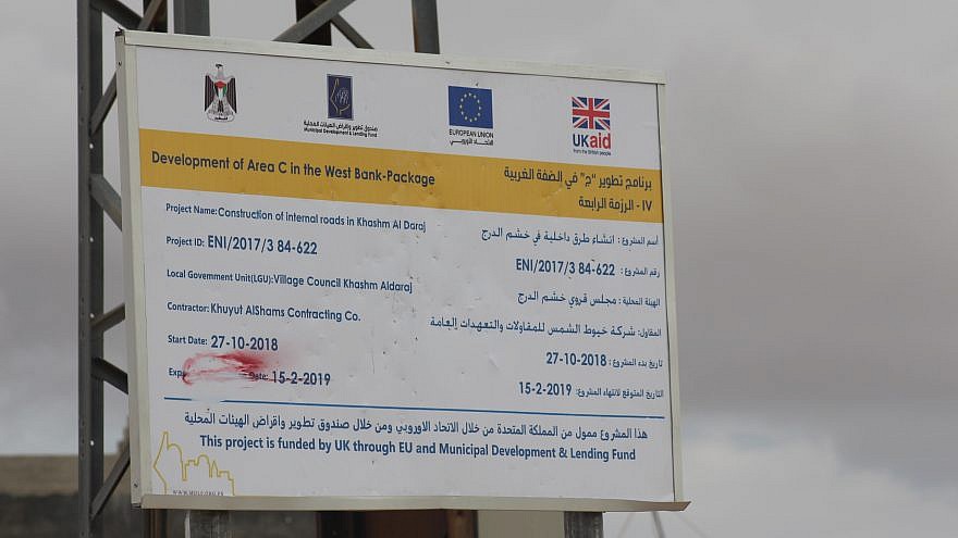
Who's funding these illegal Palestinian settlements in area C, anyway?  There have been 10,000 cases.  It has been revealed that to create a de facto Palestinian state without negotiation or even diplomatic consultation with the Israelis, European countries have pumped hundreds of millions of euros annually into illegal building.According to Israeli activist watchdog groups such as Regavim, during the last five years, illegal Palestinian settlements and infrastructure have sprawled across more than 9,000 dunams (nine square kilometers) in more than 250 Area C locations, supported by more than 600 kilometers of illegally constructed access roads and more than 112,000 meters of retaining walls and terracing. This massive works project is being conducted in broad daylight, often heralded by tall announcement placards and press releases.  I'd say that this amounts to chutzpa m'od! 

Area C, also called Judea and Samaria, comprises roughly 60 percent of the West Bank. The majority of Area C residents are Israelis—an estimated 325,000 alongside some 300,000 Arabs. Under the Oslo Accords, only the Israeli Civil Administration can authorize new construction in the zone for Israeli Jews and for Arabs alike. 

The Civil Administration is practically a "counterpart" of the Interior Ministry of Israel, and operates with its nine Israeli – District Coordination Offices (DCO), operating in the West Bank. The Civil Administration is responsible for all administrative aspects of the local population within Area C of the West Bank, and is responsible for coordinating with the Palestinian Authority, which has full administrative authority in Area A, and limited authority in Area B, as per the Oslo Accords. After 2002, with Operation Defensive Shield, the agreement in the Oslo Accords disallowing Israeli military operations in Area A was effectively abolished by the latter. The only part of the West Bank which the IDF does not enter is the Palestinian Presidential compound, the Mukataa inside Ramallah. As a working rule, the Palestinian security forces are left to operate by day, and Israeli raids take place in this area during the night.   Among other things, it is responsible for the entrance permits from the West Bank to Israel, travel permits within the West Bank, and work permits (for Palestinians seeking to enter from the West Bank to Israel in order to work). 

It also decides on matters concerning the approval of new and already built housing units in settlements. The Civil Administration that operates as part of the COGAT unit receives its budget from the Israeli government.  COGAT is responsible for implementing the Israeli government's policy in the Area C of the West Bank and vis-à-vis the Gaza Strip. In addition, COGAT constitutes the civilian authority for residential zoning and infrastructure and is responsible for addressing the needs of Israeli settlements in the West Bank. The Unit constitutes a focal point of knowledge that combines human quality and advanced technology. It coordinates the activities of government departments, I.D.F and security forces vis-à-vis the Palestinians in the West Bank and the Gaza Strip.  "Israel will continue doing everything in its power to defend its citizens and to avoid harming the residents of Gaza who are being held hostage by Hamas", the Head of the Civil Department of COGAT, Colonel Elad Goren noted.

I know what's going on. The European countries are creating a Palestine now without the support of Israel. After being rained upon by 4,300 rockets this time for 11 days, a Palestine is not looked upon with favor by many Israelis, including the new coalition. In fact, they have never shown to anyone that they would be a good normal neighbor. Egypt and Jordan have managed, though. The Palestinians have not.

https://en.wikipedia.org/wiki/West_Bank_Areas_in_the_Oslo_II_Accord

https://www.jns.org/opinion/whos-funding-illegal-palestinian-settlements-in-area-c-nearly-10000-cases/

https://www.haaretz.com/idf-to-probe-transfer-of-w-bank-land-to-settlers-1.5366132

https://www.youtube.com/watch?v=UNLykgvZ5YY  Jeff Daube's words


https://www.youtube.com/watch?v=KJg_F5sDSvE    Nadia Matar's words

https://www.jns.org/opinion/israeli-land-is-being-stolen-in-broad-daylight/

https://en.wikipedia.org/wiki/Israeli_Civil_Administration

https://en.wikipedia.org/wiki/Coordinator_of_Government_Activities_in_the_Territories